Image Source: https://www.sciencedirect.com/science/article/abs/pii/S016913682100247X
The Abitibi Greenstone Belt produced more gold than almost any other Archean terrane on Earth, and the ground is still generating discovery-stage programs across northern Ontario and Quebec. For exploration teams planning campaigns in the belt, understanding the structural controls on mineralization, the behavior of the two dominant deposit types, and the practical realities of working in remote boreal terrain is not background reading; it is the foundation of a defensible program.
Rangefront’s crews operate across Canada from British Columbia to Quebec, and the Abitibi represents one of the most technically demanding environments in the country for field execution. If you are building a program in the belt, our Canadian geological services team can help you structure it from soil sampling through geophysical surveys to NI 43-101 reporting.
Abitibi Geology: What Makes This Belt Different
The Abitibi Greenstone Belt spans roughly 700 kilometers across the Ontario-Quebec border, underlain by Neoarchean volcanic and sedimentary sequences intruded by tonalite-trondhjemite-granodiorite (TTG) suites and later potassic granites. The belt preserves a near-complete record of Archean arc, back-arc, and komatiite-bearing plume volcanism, which is precisely why it concentrates metal at scales that post-Archean greenstone belts rarely match.
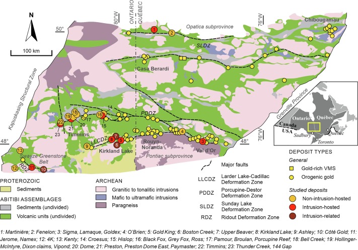
The structural architecture of the Abitibi reflects repeated phases of north-south compression and late-stage east-trending transcurrent faulting. Second- and third-order splays off the major regional faults, including the Larder Lake-Cadillac Deformation Zone, the Porcupine-Destor Fault Zone, and the Casa Berardi Tectonic Zone, are where most of the belt’s gold inventory sits. Recognizing the hierarchy of these fault systems in the field and on airborne magnetic data is the first interpretive step in any new Abitibi program.
Lithological contacts are critical structural features in the belt. The boundary between mafic volcanic assemblages and iron-formation or sedimentary units frequently acted as a rheological contrast during deformation, localizing strain and providing a conduit for auriferous hydrothermal fluids. Mapping these contacts precisely, and understanding their orientation relative to the local stress field during mineralization, drives meaningful target generation.
Orogenic Gold: The Belt’s Primary Commodity
Orogenic gold accounts for the majority of the Abitibi’s metal inventory and for the historical production at Timmins, Kirkland Lake, Val-d’Or, and Rouyn-Noranda. The genetic model is well established: gold-bearing CO2-H2O fluids derived from metamorphic devolatilization ascended along deep crustal fault zones and precipitated gold at structural traps, typically in pressure shadow zones, at lithological contacts, or within brittle-ductile transition zones.
In the Abitibi, orogenic deposits occur across a spectrum of structural settings. The Timmins-Porcupine camp concentrates along the Porcupine-Destor Fault Zone, where gold occurs in quartz-carbonate veins cutting mafic volcanics and ultramafics. The Kirkland Lake camp formed adjacent to the Larder Lake-Cadillac Deformation Zone, with gold hosted in steep shear zones cutting syenite porphyry and lamprophyre intrusives. The Val-d’Or district to the east hosts gold in extensional veins and shear-hosted systems cutting Malartic Group sediments.
For exploration purposes, the structural position of a prospect relative to the regional deformation corridor matters more than the surface geochemical signature in the early stages of a program. Soil and till sampling are effective tools for vector analysis, but the program design has to be based on the structural interpretation first, not appended to it afterward.
Alteration Indicators in Orogenic Systems
Carbonate-sericite-pyrite alteration is the standard footprint of Abitibi-type orogenic gold. Fuchsite (chromian mica) is a reliable alteration indicator where gold mineralization overprints ultramafic rocks, and tourmalinite development along shear margins in the Porcupine district has been used as a prospecting guide for decades.
Chargeability anomalies from induced polarization surveys can reflect disseminated pyrite in the alteration halo well before a drill hole confirms a gold intersection. In the Abitibi, where the primary ore often contains low visible gold with moderate sulfide content, an IP anomaly coincident with a structural target and a carbonate-sericite alteration footprint is a defensible pre-drill case.
Volcanogenic Massive Sulfide Deposits: The Polymetallic Tier
VMS deposits are the second major commodity group in the Abitibi, contributing significant copper, zinc, silver, and gold production from camps including Noranda-Horne, Kidd Creek, and Matagami. The Abitibi’s VMS endowment reflects the belt’s bimodal (mafic-felsic) volcanic stratigraphy, where synvolcanic hydrothermal circulation concentrated base metal sulfides at or near the paleoseafloor.
Kidd Creek, north of Timmins, remains one of the largest VMS deposits discovered anywhere in the world, with a steeply plunging ore body that has been mined to depths exceeding 3,000 meters. The Noranda camp in Quebec hosts a cluster of lenticular massive sulfide bodies within the Blake River Assemblage, a bimodal volcanic sequence that has been a training ground for the genetic VMS model applied globally.
From an exploration standpoint, Abitibi VMS programs rely heavily on lithogeochemical vectoring toward felsic footwall units and immobile element discrimination to identify favorable volcanic packages. Airborne magnetics and EM surveys are standard tools for identifying semi-massive to massive sulfide conductors under cover.
Recognizing VMS-Favorable Stratigraphy
The key lithogeochemical signatures for VMS exploration in the Abitibi are well documented in the literature and practiced by every senior geologist working in the belt. Felsic footwall rocks enriched in Zr, Y, and Nb relative to regional background, combined with Eu anomalies in REE profiles, indicate high-temperature volcanic hydrothermal activity. Chloritization, silicification, and stringer sulfide development in the footwall provide direct evidence of proximity to a vent complex.
If your program is targeting VMS in the Abitibi, the geological mapping effort needs to resolve stratigraphy at the unit scale. Reconnaissance-scale maps are insufficient for setting up a drill program with a defensible target.
Field Logistics in Northern Ontario and Quebec
Working in the Abitibi is not technically remote in the same sense as a fly-in program on the Precambrian Shield north of 60 degrees, but it presents its own set of logistical challenges. The terrain across the Timmins-Cochrane corridor and the Val-d’Or-Rouyn-Noranda district is largely accessible by road or forestry track, but seasonal constraints are significant and program timing directly affects what field methods are practical.
Spring breakup in northern Ontario and Quebec typically renders forest roads impassable from late March through May, depending on the year and the specific area. Summer programs contend with dense black fly and mosquito pressure, which affects crew productivity in ways that experienced field managers plan for honestly. Fall programs in September and October often deliver the best combination of access, ground conditions, and reasonable insect burden. Winter programs on frozen ground are standard in the Abitibi and can extend access into areas that are otherwise inaccessible by tracked or wheeled equipment.
Muskeg and lacustrine sediment cover is the dominant near-surface condition across much of the belt. Overburden thickness varies considerably, and till sampling programs have to account for complex glacial transport histories. Drift prospecting and indicator mineral work are established exploration methods in the Abitibi precisely because the till record preserves geochemical signals from mineralized bedrock even under significant cover.
Permitting and First Nations Consultation in Ontario and Quebec
Both Ontario and Quebec require formal consultation with First Nations communities before the approval of exploration permits on Crown land. In Ontario, the Mining Act consultation requirements apply from the early exploration permit stage and must be documented. In Quebec, consultation obligations flow from both provincial mining regulations and, in certain areas, the James Bay and Northern Quebec Agreement.
Failing to front-load consultation into a project timeline is one of the most common causes of program delays in the Abitibi. Experienced program managers treat it as a technical milestone, not an administrative afterthought.
Geophysical Methods That Work in Abitibi Programs
Airborne magnetics are the starting point for most new Abitibi programs, and Ontario and Quebec maintain public geophysical databases that provide good base coverage for most of the belt. Most advanced exploration programs acquire detailed helicopter-borne or fixed-wing magnetic surveys to improve resolution before committing to ground programs.
For ground geophysics on orogenic gold targets, dipole-dipole IP surveys oriented perpendicular to strike on structural targets are the standard approach. Array geometry depends on target depth and terrain, but n-spacings of 6 to 8 with a 25-meter or 50-meter dipole are typical for targets in the 100 to 300 meter depth range. Chargeability inversions in Res2DInv or the UBC-GIF IP inversion suite provide the model that drives the drill section. Rangefront’s geophysical survey services team designs array geometry based on the deposit model and the target depth, not default parameters.
For VMS-style conductors, ground FDEM surveys provide cost-effective coverage in Abitibi terrain, where forest access allows reasonable line-cutting costs. Electromagnetic responses from semi-massive sulfide bodies can be distinguished from graphitic sediment responses by their decay characteristics and by comparison with the magnetic signature.
Ground magnetic surveys over detailed grid areas remain useful for resolving local structural geometry and identifying magnetite-destructive alteration associated with VMS footwall hydrothermal systems.
Soil and Till Sampling in the Abitibi
Till sampling is the geochemical method most suited to the Abitibi’s covered terrain, and it requires a different approach than residual soil sampling in unglaciated terrane. Sample sites need to be positioned in relation to the local ice flow direction to capture downice dispersion trains from bedrock sources. The Ontario Geological Survey and the Quebec Geological Survey have published detailed Quaternary mapping for most of the belt, and this data is essential for till sampling program design.
Soil sampling in areas of thinner till cover, particularly on ridge crests where the overburden is coarser and better drained, can still produce interpretable geochemical patterns for orogenic gold targets where the alteration footprint is broad. The B-horizon is the standard sample medium, and aqua regia or multi-acid digestion with ICP-MS analysis is appropriate for gold plus the full base metal suite.
Rangefront’s field crew services team executes soil sampling programs in Abitibi-style terrain with GPS-verified sample locations, chain-of-custody documentation, and sample preparation protocols that meet NI 43-101 standards from the first sample bag. That documentation matters when the program advances to a resource estimate.
NI 43-101 Compliance from Day One
Every exploration program in Canada that may eventually support a public disclosure or technical report needs to be designed and executed with National Instrument 43-101 compliance in mind from the outset. In Ontario and Quebec, it is the standard that governs whether your data will be usable by a Qualified Person when it comes time to write the technical report.
The practical implication for Abitibi programs is that sample collection, QA/QC protocols, chain-of-custody documentation, and geological logging standards must be established and followed from day one. Retroactively reconstructing QA/QC records for a NI 43-101 technical report is difficult and sometimes impossible. Rangefront’s field protocols are built around NI 43-101 technical reporting requirements, so the data your crews collect in the field will support the report your Qualified Person needs to write.
Abitibi Greenstone Belt —
Frequently Asked Questions
Planning an exploration program in the Abitibi? These answers cover deposit targeting, geochemical sampling under glacial cover, provincial permitting, and seasonal access — drawn from Rangefront's active field operations across Ontario and Quebec.
Final Thoughts
If you are building an exploration program in the Abitibi Greenstone Belt in Ontario or Quebec, talk to Rangefront’s field and geophysical team about program design before you finalize your budget. We have executed programs across the Canadian Shield and understand the geological, logistical, and regulatory specifics of the belt. Request a project quote by calling (775) 753-6605 or emailing info@rangefront.com. Our Canadian operations are based out of Vancouver, BC, and we are set up to mobilize crews to northern Ontario and Quebec on your timeline.

ABOUT THE AUTHOR
BRIAN GOSS
President, Rangefront Mining Services
Brian Goss brings over 20 years of experience in gold and mineral exploration. He is the founder and President of Rangefront, a premier geological services and mining consulting company that caters to a large spectrum of clients in the mining and minerals exploration industries. Brian is also a director of Lithium Corp. (OTCQB: LTUM), an exploration stage company specializing in energy storage minerals and from 2014 to 2017, he fulfilled the role of President and Director of Graphite Corp. (OTCQB: GRPH), an exploration stage that specialized in the development of graphite properties. Prior to founding Rangefront, Brian worked as a staff geologist for Centerra Gold on the REN project, as well as various exploration and development projects in the Western United States and Michigan. Brian Goss holds a Bachelor of Science Degree with a major in Geology from Wayne State University in Michigan.
You may also be interested in...

Impact of Recent U.S. Tariffs on the Mining and Exploration Industries
The Trump administration has promised sweeping trade measures aimed at recalibrating the United States' global trade position. Explore how tariffs could affect the mining sector from increased operational costs to the reshaping of global supply chains and what...

How Trump’s 2025 Executive Order on American Mineral Production Could Reshape American Mining
On March 20, 2025, the White House issued an executive order titled “Immediate Measures to Increase American Mineral Production,” a directive aimed at expanding domestic access to critical minerals essential for energy, defense, and high-tech manufacturing. The order...

Ontario’s “One Project, One Process” Bill: What It Means for the Economy, Industry, and Indigenous Communities
Ontario’s new "One Project, One Process" bill promises to overhaul how major projects are approved in the province. Designed to streamline regulatory processes while maintaining environmental stewardship and Indigenous consultation, the bill could significantly...

Mining Jobs Outlook in Canada 2025
Mining continues to be a vital part of Canada’s economy in 2025, supporting diverse industries from clean energy to electronics production. With significant reserves of resources like gold, nickel, potash, and lithium, the sector remains strong despite shifting market...

Are Mining Jobs in Demand In the U.S. in 2025?
In 2025, mining jobs will remain in high demand, driven by the continued need for a wide range of minerals—including metals critical to emerging technologies such as electric vehicles and renewable energy systems. Although the industry can fluctuate due to...

Introduction to Soil & Rock Chip Sampling in Mineral Exploration
Mineral exploration involves multiple techniques aimed at identifying valuable mineral deposits in a given region. Two fundamental early-stage methods are soil sampling and rock chip sampling. Both help geologists and exploration companies infer the presence of...

Are Geologists in High Demand in Canada? Exploring Opportunities in a Resource-Rich Nation
Canada’s vast and diverse landscape is not just a geographical marvel—it’s a treasure trove of natural resources that fuel industries worldwide. From being a global leader in mineral production to advancing renewable energy initiatives, the country’s economic growth...

Mining Careers in Canada: Exploring Job Availability in a Thriving Industry
Canada has a rich history of mining, with its vast and diverse landscape providing a wealth of mineral resources. From gold and silver to potash and diamonds, the mining industry has played a significant role in the Canadian economy for decades. While the demand for...

Should I Be a Miner or a Geologist? A Career Guide for Aspiring Professionals
The mining and geology industries offer exciting, dynamic career paths that are essential to the global economy. From uncovering the raw materials used in everyday life to advancing scientific knowledge, both professions play important roles. However, deciding between...

Best Practices for Optimizing Your Mining Geology Project with Contract Labor
Contract labor has become an indispensable component of modern mining geology projects. With the mining industry’s increasing demand for flexibility, scalability, and specialized expertise, integrating contract labor effectively can deliver measurable benefits. By...

Top Five Geophysical Survey Techniques and When to Use Them in Mining Geology
Geophysical survey techniques are important tools in mining geology, enabling the exploration and evaluation of mineral resources beneath the Earth's surface. With advances in technology, these geophysical survey methods have become increasingly sophisticated,...

Magnetics Studies in Mineral Exploration and Mining: An In-Depth Guide
Magnetics studies are a popular geophysical service in the mining and exploration industries, playing a crucial role in identifying mineral resources, mapping subsurface geology, and assisting in the decision-making process throughout the mining lifecycle. Leveraging...