A magnetic survey is only as good as the data density behind it. Two survey platforms, flown and walked over the same ground on the same program, can double that density without doubling your budget or your schedule.
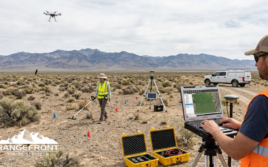
That is the logic behind Rangefront’s approach to combined UAV and ground magnetic surveys. Rather than choosing between a drone mag for speed and a backpack mag for resolution, both platforms run concurrently on the same property, sharing the same base station and the same field crew. The result is a richer dataset than either method produces alone, and the geophysicist at the processing stage has the geometry to distinguish real structural features from sensor-altitude artifacts. For a deeper look at how Rangefront designs and executes these programs, explore our magnetic survey services.
What Magnetic Susceptibility Is Actually Measuring
Every lithology has a magnetic susceptibility value. Magnetite content drives most of the signal in exploration targets, and susceptibility contrasts between rock units are what magnetic surveys detect and map. Mafic intrusives, iron-rich skarns, magnetite-bearing porphyry halos, and certain alteration zones all produce responses that stand out against sedimentary or felsian country rock.
Knowing what you are measuring matters before choosing how to measure it. A target with subtle susceptibility contrast between units needs tighter line spacing and a sensor close to the ground. A target with strong, broad magnetic relief can be captured efficiently from altitude. Many programs have both conditions across the same property, which is exactly where a combined platform approach starts to make economic sense.
Ground Mag: What You Gain by Walking the Lines
A geologist wearing a backpack magnetometer, walking 50-meter or 25-meter line spacing across a grid, is collecting data at a consistent sensor height of roughly one meter above ground. That proximity matters. Small-scale features, narrow shear zones, discrete dykes, contact zones with limited lateral extent, all of these register more clearly in ground data than in data collected from 30 or 40 meters AGL.
Rangefront’s crews use two backpack magnetometer units in the field. One walks the grid lines. The other operates as a roving second unit, which allows crew pairing on safety-compliant programs without sacrificing coverage rate. On a typical day, a ground crew walks roughly five line-kilometers per person. That is solid production, but terrain, access, and line density can compress it significantly in rough country.
Ground mag also produces the highest-fidelity dataset for later comparison. When the drone data comes in and shows an anomaly, the ground data over the same corridor tells you whether that anomaly holds up at surface resolution. That cross-check is where combined programs earn their value.
Drone Mag: Coverage Rate and the Speed Advantage
A UAV magnetometer system flying at consistent terrain clearance can cover roughly ten line-kilometers in a day under good conditions. Walk five, fly ten. The production difference is not subtle.
Rangefront owns its drone mag equipment outright, which removes the scheduling delays and markup that come with subcontracting the platform. The system includes LiDAR and photogrammetry capability, which serves two purposes: it supports terrain-following flight paths that hold consistent sensor altitude over variable topography, and it generates a photogrammetric surface model that can support orthophoto interpretation alongside the magnetic data. The combination of LiDAR-guided flight and consistent drape altitude is what keeps drone mag data defensible at the processing stage.
The limitation is resolution. Drone mag data collected at standard survey altitudes shows less detail than ground mag over the same corridor. Narrow features and shallow contacts that a ground sensor resolves clearly will often appear smeared or subdued in the drone dataset. This is because sensor-to-target distance attenuates the short-wavelength signal. A geophysicist interpreting drone mag data alone needs to account for that, and any anomaly that looks sharp in the drone data probably has some lateral extent worth investigating.
Why One Base Station Serves Both Platforms
The Earth’s field fluctuates throughout the day due to ionospheric activity, and those fluctuations contaminate the total-field measurements your sensor collects. A base station magnetometer, fixed at a known location and logging continuously, records the ambient field variation so that drift can be removed from the mobile sensor data in post-processing.
Rangefront runs a single base station that handles drift correction for both the ground crew and the drone. Logistically, this works because both platforms are operating on the same property at the same time, within the correction radius of the base. It eliminates the need for a second base station instrument, reduces the setup footprint, and keeps the datasets on a consistent correction baseline. When you merge ground and drone data, both datasets have been corrected against the same reference, which simplifies the integration considerably.
Combined Programs and Safety-Driven Crew Coordination
Many mining company clients operate under stringent field safety programs that require personnel to work in pairs. That requirement shapes how combined mag programs are structured in practice.
On a combined drone and ground program, the UAV operator and the ground mag technician work the same area together rather than splitting across different parts of the property. The drone operator flies lines while the ground tech walks adjacent or parallel lines. The two platforms collect data over overlapping corridors, the safety requirement is met without a dedicated second person standing idle, and production from both platforms is captured simultaneously. It is a crew-efficiency solution as much as a data-quality one.
This pairing also means that if a ground condition changes, a fence line appears, or access becomes unsafe, both crew members are in proximity to make that call together. Remote programs in BC, the Yukon, or interior Nevada do not always have the luxury of quick extraction. Keeping the crew paired and mobile on the same survey corridor is the practical answer.
What the Geophysicist Does with Double the Data
Running both platforms over the same property generates a data volume that a single-method program would not produce. The back-end processing time increases accordingly.
The geophysicist’s job on a combined program involves merging two datasets with different line spacings, sensor altitudes, and resolution characteristics into a single interpretable product. Ground mag data typically goes through standard total-field reduction, diurnal correction, and leveling before gridding. Drone data goes through the same correction workflow with additional altitude normalization. Where the two datasets overlap spatially, the interpreter can compare the signatures directly: features present in both datasets at consistent amplitudes are almost certainly real; features that appear in the drone data but not in the ground data warrant closer scrutiny and may reflect altitude-related artifacts or broad regional sources.
The outcome is a more defensible interpretation. When you bring combined data to a geophysical survey program review or a technical report, you have corroboration from two independent sensor geometries. That matters when anomalies are guiding drill decisions.
When a Combined Program Makes Sense
Not every property justifies the combined approach. A small, single-target claim block with tight ground access may be better served by a high-density ground mag survey alone. A large claim package with variable terrain, where full ground coverage would take multiple field seasons, is a strong candidate for drone mag as the primary platform with selective ground infill over priority anomalies.
The combined program works best when the property is large enough that drone coverage provides meaningful time savings, and the target model is specific enough that ground-level resolution over key corridors adds real interpretive value. Porphyry programs with broad magnetic halos and discrete late-stage faults, epithermal systems where structural corridors control mineralization, skarn targets with magnetite-bearing contact aureoles, these deposit types benefit from seeing the large-scale magnetic architecture in the drone data and the fine-scale structural expression in the ground data simultaneously.
Where budgets allow and targets warrant it, induced polarization surveys run after a combined mag program to separate chargeability responses from the magnetic framework. The two datasets together give a geophysicist substantially more to work with before committing to a drill hole.
Talk to Rangefront’s Geophysical Team About Your Magnetic Survey Program
Rangefront’s geophysical team designs magnetic survey programs from the ground up, including combined drone and ground mag programs for properties across Nevada, British Columbia, the Yukon, Idaho, and Alaska. If you have a target that needs better magnetic coverage, or a large claim package that ground mag alone would take too long to cover, contact the team at the Elko office to talk through the program design.
Call (775) 753-6605, email info@rangefront.com, or request a project quote directly. Tell us your target model, your claim area, and your timeline, and we will tell you what a combined program can realistically deliver.
Combined Drone & Ground Mag —
Frequently Asked Questions
Practical answers on data volume, platform roles, base station logistics, processing timelines, and deposit targets — from Rangefront's geophysical survey team.

ABOUT THE AUTHOR
BRIAN GOSS
President, Rangefront Mining Services
Brian Goss brings over 20 years of experience in gold and mineral exploration. He is the founder and President of Rangefront, a premier geological services and mining consulting company that caters to a large spectrum of clients in the mining and minerals exploration industries. Brian is also a director of Lithium Corp. (OTCQB: LTUM), an exploration stage company specializing in energy storage minerals and from 2014 to 2017, he fulfilled the role of President and Director of Graphite Corp. (OTCQB: GRPH), an exploration stage that specialized in the development of graphite properties. Prior to founding Rangefront, Brian worked as a staff geologist for Centerra Gold on the REN project, as well as various exploration and development projects in the Western United States and Michigan. Brian Goss holds a Bachelor of Science Degree with a major in Geology from Wayne State University in Michigan.
You may also be interested in...

How to Find Mining Job Openings
Metal ore mining jobs are expected to grow by 16.3% over the next 10 years which is over double the expected national workforce growth rate. With higher commodity prices and an electric energy trend that positively impacts mining for copper, nickel, lithium, and more,...

What is Mining Contract Labor?
If you are searching for a career in the mining industry or are searching for temporary laborers for your mining project, you may have seen the phrase “mining contract labor.” This refers to employees who are hired on a contract basis for a temporary or seasonal need....

Are Mining Jobs in Demand?
If you are in the mining industry or considering entering it, you may be wondering if mining jobs are in demand. MINING INDUSTRY OUTLOOK 2021 While the COVID-19 pandemic presented new challenges to the mining industry, resulting in many commodity prices decreasing...

About Rangefront’s Mining Recruiting Services
Rangefront offers staffing and recruiting services for the mining and geology industries. Whether you are looking for contract or seasonal labor or are looking for a direct hire, our recruiting experts can help. We know you have a lot of options when it comes to...